-
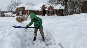 The National Weather Service in Wilmington, Ohio, says more snow fell on Jan. 25, 2026, in the Dayton area than the Blizzard of 1978. Several counties remain on Level 2 snow emergencies.
 -
 A local state of emergency has been declared in the Dayton area as Winter Storm Fern dumps more than a foot of snow on Sunday, Jan. 25, 2026. Clark and Champaign declared a Level 3 snow emergency.
 -
 The National Weather Service says La Nina is dominating our weather patterns this year.
 -
 Two tornadoes touched down in Clark County on Saturday night.The National Weather Service says the first hit at 9:15 p.m. one mile southeast of North Hampton.
 -
 An Ohio meteorologist fired by the Trump administration's cutbacks worries about the accuracy of weather forecasts and the ability to keep communities safe during severe weather.
 -
 The National Weather Service has issued an Extreme Heat Watch for southwest Ohio, from Sunday, June 22, through the evening on Tuesday, June 24. Daily high temperatures are forecast to rise into the 90s with a heat index above 100.
 -
 A power pole leaning over a major roadway is one of several incidents of damage from gusty thunderstorms that blew through the area.
 -
 The National Weather Service says wind chill values will be dangerously cold on Monday, Tuesday, and Wednesday mornings in the Miami Valley.
 -
 During the week of January 6, southwest Ohio’s daytime temperatures will settle in the 20s, with only glimpses of sun. The area is also bracing for more snow later in the week.
 -
 The National Weather Service in Cleveland confirmed an EF-0 tornado in Huron County. This was the 63rd tornado in Ohio this year, surpassing the previous record set in 1992.
 -
Ohio averages around 21 tornadoes a year. So far this year, there have been 54 recorded and it's not yet June.
-
 The National Weather Service surveyed damage Wednesday following severe weather on March 7.
© 2026 WYSO
Our Community. Our Nation. Our World.
Play Live Radio
Next Up:
0:00
0:00
Available On Air Stations


