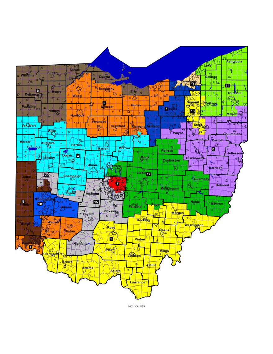
Many Kent residents got their first look at their new congressional district at a community conversation hosted by the League of Women Voters of Ohio and Kent Thursday night. The Ohio Redistricting Commission has until the end of the day Friday to come up with a bipartisan agreement on a congressional map for the state. The commission unveiled a map Thursday afternoon, which would push two districts more Republican and push one more Democrat.
This is the latest attempt from the commission to pass a constitutional map after a years long saga of unconstitutional maps, political fighting and gerrymandering.
The new map pushes the 13th Congressional District more Democrat, by adding Kent and Streetsboro. Currently, the district covers all of Summit County, parts of Stark County, including Canton; and a small part of Portage County and is represented by Rep. Emilia Sykes, a Democrat.
"We added Kent and Streetsboro, and we took out - and by we I mean the commission - took out Canal Fulton, Lawrence Township," Andrew Green with the League of Women Voters said. "In Stark County, they took out part of the city of Massillon."
Sykes, who has won election in one of the most competitive districts in the state twice, is now thought to have an easier chance of reelection.
The new map pushes the 9th Congressional District, which includes several counties in Northwest Ohio and the city of Toledo, and the 1st Congressional District, which includes parts of Hamilton County, including Cincinnati, as well as the more rural Clinton and Warren counties, further right. Both seats are currently occupied by Democrats - Rep. Marcy Kaptur in the 9th district and Rep. Greg Landsman in the 1st district, who now may face a harder time getting reelected in their new districts.
Kent residents packed the meeting and shared their disappointment with the commission. Most were critical of how the commission has operated.

"They have been negotiating behind closed doors, not engaged in a public process, completely ignoring voters," Common Cause Ohio Executive Director Catherine Turcer said.
Jill, who lives in Kent and was attending Thursday's conversation, said she was in favor of her city being moved to the 13th district.
"In some ways I support that, because I think Kent is probably more aligned to some of the more urban issues," she said. "And I know I feel a little bit more connected to Stow and Cuyahoga Falls than I do to the people in Mahoning County for example."
Currently, Kent and most of Portage County are in the 14th Congressional District, which also includes all of Ashtabula, Geauga, Lake and Trumbull counties. The new map proposes adding half of Mahoning County into the 14th district, making it the third county to be split just in Northeast Ohio.
"The new map that was just introduced today actually has 15 county splits," Green said. "It has one more county split than is necessary, and it's actually in this region of the state. We split Mahoning, Portage and Stark counties, and we only need to split two of those three mathematically."

The new map also makes significant changes to the 7th Congressional District, which currently covers some Cleveland suburbs, all of Medina and Wayne counties and a top portion of Holmes County.
"Again, cracking the majority folks of color in the Cleveland suburbs, pairing them with counties like Ashland," League of Women Voters of Ohio Program Coordinator Trevor Martin said.
The proposed changes to the 7th district would still include some Cleveland suburbs and all of Medina County but cuts Wayne County in half and adds all of Ashland County.
Opponents of the new map also take issue with the number of municipalities it splits.
"They split the community of Wooster," Martin said. "Over in District 4 and 5, they've got Mansfield completely cut in half."
In Mahoning County, Austin Township is split in half, and in Stark County, Uniontown is split in half, he said.
"Tomorrow, they're likely to finalize a map that doesn't focus on voters, right?," Turcer said. "And it does damage, right?"
Despite qualms opponents of the new map have, Democrats are likely to sign onto the map, the Statehouse News Bureau reports. The commission is running against the clock. It needs both Democrats to agree on the map by Friday, and if that doesn't happen, the Republican supermajority can pass their own redistricting plan in the legislature without any Democrats by Nov. 30.


